Synoptic-Scale Meteorological Clustering Analysis of Volcanic Ash Inflow into the Korean Peninsula Following the Eruption of Mt. Baekdu
Ⓒ The Korean Environmental Sciences Society. All rights reserved.
This is an Open-Access article distributed under the terms of the Creative Commons Attribution Non-Commercial License (http://creativecommons.org/licenses/by-nc/3.0) which permits unrestricted non-commercial use, distribution, and reproduction in any medium, provided the original work is properly cited.
Abstract
To investigate the frequency and trajectories of volcanic ash from Mt. Baekdu reaching the Korean Peninsula, a forward trajectory analysis was conducted using the Hybrid Single-Particle Lagrangian Integrated Trajectory (HYSPLIT) model. Through a cluster analysis of air parcel trajectories, we identified the main pathways of the volcanic ash from Mt. Baekdu entering the Korean Peninsula and analyzed the synoptic meteorological conditions on those days. The frequency of volcanic ash reaching the Korean Peninsula was 82 times at an altitude of 1000 m and 70 times at 2000 m, with an increasing trend from 2016 to 2022. This increase is attributed to the weakening of westerly winds and the strengthening of north-south winds due to global warming. Five and three trajectory clusters were classified at 1000 m and 2000 m, respectively. At a starting altitude of 1000 m, most air parcels originating from Mt. Baekdu entered the Korean Peninsula under weather conditions (C2, C3) where the pressure gradient from the northwest to the southeast was small, resulting in weak northerly winds. C2 and C3 showed shorter trajectories, which occurred in all seasons, except summer. At a starting altitude of 2000 m, air parcels mostly passed over the Korean Peninsula in a synoptic pattern similar to that at 1000 m in altitude; however, the air parcels had simpler paths and less frequent inflow. C2, at a starting altitude of 2000 m, originates from Mount Baekdu, crosses the center of the Korean Peninsula, and continues to the central region. At a starting altitude of 1000 m, volcanic ash can enter the Korean Peninsula when there is no strong low-pressure system to the southeast of the Korean Peninsula, whereas at 2000 m, volcanic ash can enter the Korean Peninsula when the Siberian high-pressure system is weak.
Keywords:
Mt. Baekdu, Volcanic ash, HYSPLIT model, Forward trajectory analysis, Cluster analysis1. Introduction
Volcanic eruptions occur frequently in various regions worldwide (Ramirez et al., 2022). The eruption of Eyjafjallajökull volcano in Iceland in April 2010 caused significant economic losses as volcanic ash spread across the European continent, disrupting air traffic and impacting tourism and precision machinery industries, not only in Iceland but also in neighboring European countries (Jiang et al., 2013). Since then, volcanic disasters that were previously considered local events have been recognized as global disasters. During a volcanic eruption, lava flows and volcanic ash, along with volcanic gases, such as sulfur dioxide, carbon dioxide, and water vapor, are ejected on the ground and in the atmosphere. This can lead to deteriorating air quality and impact global climate change by lowering the average surface temperature and weakening the hydrological cycle. Additionally, such eruptions can cause socioeconomic and human damage (Sun et al., 2020; Man et al., 2021). Although lava and pyroclastic flows from volcanic eruptions cause damage primarily in areas close to the volcano, volcanic ash and gases can spread over several kilometers, affecting not only the region surrounding the eruption but also neighboring countries. Therefore, understanding the transport pathways of these volcanic materials is crucial (Lee et al., 2017; Park et al., 2020).
East Asia has many active and dormant volcanoes, including Mt. Baekdu, Mount Sakurajima, Mount Aso, Mount Daisen, and Mount Kikai (Han et al., 2019). In particular, Mt. Baekdu is located approximately 500 km from the Seoul metropolitan area and is the only volcano on the northern part of the Korean Peninsula. Since a minor eruption in 1925, Mt. Baekdu has been a dormant volcano with no volcanic activity. However, since 2002, there has been an increase in volcanic seismic activity, a heightened earthquake magnitude, rising water temperature of Heaven Lake, increased volcanic gas emissions, and abnormal surface deformations observed at Mt. Baekdu. As a result, it has been evaluated as an active volcano with the potential for eruptions (Yun, 2013; Seo et al., 2016). According to domestic and international volcanologists, Mt. Baekdu, identified as an active volcano, has a 99% probability of erupting over the next 20 years (Lee et al., 2018). Accordingly, many studies have been conducted on the effects of a Mt. Baekdu eruption on the Korean Peninsula. Lee et al.(2012) conducted numerical experiments to analyze the dispersion characteristics of volcanic ash from Mt. Baekdu under various volcanic explosivity indices and their impact on the Korean Peninsula. Lower eruption intensities resulted in significant regional variations in volcanic ash deposition within the Korean Peninsula. Kim(2011) used lava flow, volcanic ash, and tephra models to predict the impact range of volcanic ejecta during a Mt. Baekdu eruption. The results confirmed that lava flows extend towards the Chinese side, whereas volcanic ash spreads towards the northern regions of North Korea. Kim et al.(2016) analyzed air mass trajectories and found that air mass trajectories originating from Mt. Baekdu had a high residence time in the Gangwon Province, as they mainly stagnated near Mt. Baekdu. Park et al.(2020) conducted long-term virtual eruption simulations of major volcanoes around the Korean Peninsula, including Mt. Baekdu, using LADAS-VA, a three-dimensional numerical model for volcanic ash dispersion. The eruptions of Mt. Baekdu affected the Korean Peninsula throughout most of the year, with a higher average number of impact days observed during summer. Additionally, seasonal variations have a greater influence than year-to-year variations. Lee et al.(2023) also analyzed the impact of volcanic ash from surrounding volcanoes on the Korean Peninsula based on volcanic eruption scenarios using FALL3D. If Mt. Baekdu erupted with a volcanic explosivity index (VEI) of 7, there is a significant likelihood that the entire Korean Peninsula would experience substantial impacts, particularly from July to September.
With the increased interest in the eruption of Mt. Baekdu, various studies have been conducted. However, most of these studies have primarily focused on scenario analyses using volcanic ash dispersion models over short periods. There has been limited research on the interannual variations and meteorological conditions on the days when volcanic ejecta from Mt. Baekdu could have affected the Korean Peninsula.
Therefore, we analyzed the air mass transport paths for four years (2016, 2018, 2020, and 2022) to identify and select the days when volcanic ash would be transported to the Korean Peninsula in the event of Mt. Baekdu erupting and analyzed the interannual variability of volcanic ash flow into the Korean Peninsula and its causes. In addition, cluster analysis was conducted on the selected days to understand the trajectory of volcanic ash flows into the Korean Peninsula by altitude based on the meteorological fields. We analyzed the synoptic weather patterns for these specific cases, as it is important to clearly analyze the meteorological conditions of volcanic ash flows.
2. Data and Methodology
2.1. Models and data
Mt. Baekdu, the highest peak of the Changbai Mountains, is located at the border region (41.99°N, 128.08°E) between Yanggang Province, Samjiyon County, North Korea, and Jilin Province, China. It is a complex volcanic system consisting of a lava plateau, shield volcanoes, stratovolcanoes, and a caldera (altitude: 2750 m). Heaven Lake, a caldera lake that formed on the top of Mt. Baekdu after a massive explosive eruption in the Holocene, has an area of 9.82 km2 and a maximum depth of 374 m. Approximately 2 billion tons of water are stored in Heaven Lake (Lee and Yun, 2011; Yun and Lee, 2012). In this study, Mt. Baekdu was selected as the volcano because it is the only active volcano located in the northern part of the Korean Peninsula and the possibility of volcanic eruptions is constantly increasing (Fig. 1).
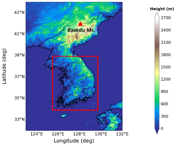
Location of the Mt. Baekdu. Red box indicate the area of the Korean Peninsula reached by air parcels originating from Mount Baekdu.
A forward trajectory analysis was performed to identify the transport pathways of volcanic ash during the eruption of Mt. Baekdu. The Hybrid Single-Particle Lagrangian Integrated Trajectory (HYSPLIT) Version 5.2.1 model, developed by the National Oceanic and Atmospheric Administration (NOAA), was used for the forward trajectory analysis. The HYSPLIT model is a comprehensive system that calculates atmospheric advection and dispersion to simulate not only the trajectories of air parcels but also their complicated transport, dispersion, chemical transformation, and deposition (Qor-el-aine et al., 2022; Nam et al., 2023). It is widely used to determine aerosol transport pathways from biomass burning, industrial emissions, and volcanic eruptions because it allows for the forward and backward tracking of air parcels (Nawaz et al., 2023). To perform the HYSPLIT model, meteorological data such as horizontal and vertical wind fields, temperature, and sea-level pressure are required (Jung et al., 2013). We used the reanalysis data from the National Centers for Environmental Prediction (NCEP) Final (FNL) Operational Global Analysis (ftp://ftp.arl.noaa.gov/pub/archives/reanalysis) with a horizontal resolution of 1° × 1° as input data.
To analyze the pathways of volcanic emissions entering the Korean Peninsula and their annual changes, forward trajectories of air parcels over a 72-h period were conducted for 2016, 2018, 2020, and 2022. Because of the burden of calculating the entire period from 2016 to 2022 and to clarify trends, this study was initially conducted at two-year intervals. The movement paths of air parcels varied depending on the altitude of the starting point. Therefore, this study analyzed air parcel trajectories at altitudes of 1000 m and 2000 m, considering the altitudes at which volcanic eruptions directly affect air quality on the Korean Peninsula. The HYSPLIT model uses starting altitudes of 1000 m and 2000 m above the 2750 m elevation of Baekdu Mountain.
In addition, sea level pressure and U and V wind components from the FNL reanalysis data were used to analyze the synoptic meteorological field when the volcanic ash enters the Korean Peninsula.
2.2 Cluster analysis
Cluster analysis is a method of classifying groups based on the similarity of characteristics within each dataset. By grouping trajectories, this method minimizes the variability of trajectories within a cluster and maximizes the variability between clusters (Hafner et al., 2007; An et al., 2015; Nauth et al., 2023). In this study, cluster analysis was performed on the trajectories generated using the k-means clustering algorithm to identify the tendency of volcanic ash that erupted from the target area to enter the Korean Peninsula. Each trajectory generated an endpoint every hour, resulting in 72 endpoints. Trajectory clustering was based on the total spatial variance (TSV) method. In the clustering process, the following values were calculated: the spatial variance (SV) of each cluster, which is the sum of the squared distances between the endpoints in each trajectory within the cluster and the points corresponding to the average trajectory of the cluster; the cluster spatial variance (CSV), which is the sum of the SV values of all trajectories within a cluster; and the TSV, which is the sum of the CSV of all clusters. The number of clusters was determined by the point at which the TSV increased minimally (Su et al., 2015; Ma et al., 2019). SV can be calculated as shown in Eq. 1.
| Eq. (1) |
where P is the position vector of each individual trajectory j, M is the position vector of the average trajectory of cluster i, and k denotes the endpoint of the trajectories belonging to each cluster. The CSV of cluster i is the sum of the SVs of all the trajectories in the cluster, as shown in Eq. 2.
| Eq. (2) |
The TSV is the sum of the CSV for all the clusters, as shown in Eq. 3.
| Eq. (3) |
3. Results
To identify the days when the Korean Peninsula was affected by volcanic ash during the eruption of Mt. Baekdu, an air parcel trajectory analysis was conducted by altitude for four specific years (2016, 2018, 2020, and 2022). The occurrence frequency and annual change in trajectories passing over Korea among the trajectories generated by HYSPLIT are shown in Table 1. Fig. 2 shows the annual change in the frequency of volcanic ash reaching the receptors based on the starting altitude of HYSPLIT. The trajectories of air parcels originating from Mt. Baekdu were analyzed over a 72-h period. Air parcels were considered to have reached a receptor if the trajectories passed through or had endpoints within the designated area of South Korea (Fig. 1, red box), indicating the potential arrival of volcanic ash. The trajectories of the volcanic ash that erupted from Mt. Baekdu passed over Korea 82 times at 1000 m and 70 times at 2000 m (Table 1). The overall frequency of volcanic tephra-reaching receptors increased. When the starting altitude was 1000 m, the frequency of air trajectories reaching the receptor was 10 times in 2016. It steadily increased to 19 times, 22 times, and 31 times in 2018, 2020, and 2022, respectively, with the highest frequency in 2022, an increase of approximately 3 times compared to that in 2016 (Fig. 2a). At a starting altitude of 2000 m, the frequency of air trajectories reaching the receptor increased in all years except for 2020. After increasing from 12 times in 2016 to 20 times in 2018, it decreased to 15 times in 2020, but increased to 23 times in 2022, a change of approximately 2 times compared to that in 2016. This suggests that the frequency of volcanic ash passing over the Korean Peninsula has increased (Fig. 2b). The frequency of volcanic ash erupting from Mt. Baekdu reaching the receptors increased regardless of the starting altitude. This can be attributed to changes in the synoptic circulation patterns, such as decreased east-west winds and increased north-south winds, likely caused by global warming. In the case of seasonal occurrence frequency, volcanic ash from Mt. Baekdu, starting at an altitude of 1000 m, had the highest frequency of entering the Korean Peninsula in autumn, with 27 occurrences, but it occurred evenly in all seasons except summer. However, for the 2000-m starting altitude, the frequency of volcanic ash from Mt. Baekdu impacting the Korean Peninsula was 30 days in spring, which was significantly higher than that in other seasons (Fig. 3).
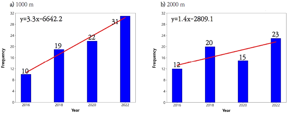
Annual variations in the days when volcanic ash at starting altitude of a) 1000 m and b) 2000 m in reaches the Korean Peninsula based on the HYSPLIT model.
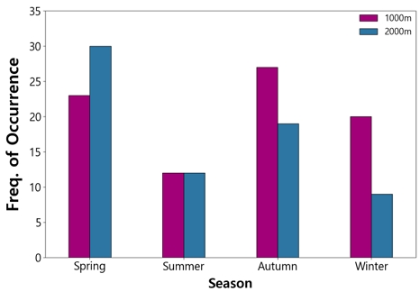
Seasonal frequency of days when volcanic ash reaches the Korean Peninsula based on the starting altitude 1000 m and 2000 m in the HYSPLIT model.
A synoptic meteorological analysis was performed on days when the air trajectory from Mt. Baekdu passed over the Korean Peninsula. At altitudes of 1000 m and 2000 m, high pressure was observed over the northwest, and low pressure was observed over the southeast of the Korean Peninsula, resulting in a northwest-to -southeast gradient of atmospheric pressure. Consequently, the northerly winds prevailed over the Korean Peninsula in both cases (Fig. 4). However, there were differences between the two cases. At 1000 m, a strong high pressure was located northwest of the Korean Peninsula, and a weak low pressure was located over the Japanese mainland, resulting in a significant pressure gradient from the northwest to the southeast. In contrast, weak high and low pressures were located northwest of the Korean Peninsula and over the Japanese mainland, respectively, resulting in a relatively small pressure gradient from the northwest to the southeast at 2000 m.
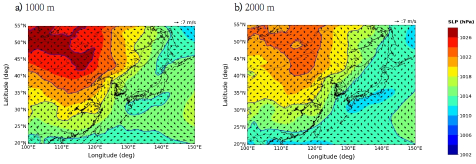
Distributions of mean sea-level pressure and 1000 hPa wind vectors on the days when volcanic ash reaches the Korean Peninsula with the HYSPLIT model starting altitudes of a) 1000 m and b) 2000 m.
To understand the characteristics of the volcanic ash trajectory from Mt. Baekdu entering South Korea, cluster analysis was conducted on the trajectories that entered the Korean Peninsula during the study period (1000 m: 82, 2000 m: 70). Table 2 presents the frequency of occurrence and annual changes for each cluster resulting from the cluster analysis of trajectories starting at an altitude of 1000 m, and Fig. 5 shows the seasonal occurrence frequency for each cluster. Trajectories passing over the Korean Peninsula at a starting altitude of 1000 m were classified into five clusters (C1–C5). The frequencies of occurrence for each cluster were as follows: C1 – 4.9%, C2 – 39.0%, C3 – 43.9%, C4 – 7.3%; and C5 - 4.9%. The combined proportions of C2 and C3 accounted for over 80% (Table 2). When examining the seasonal occurrence frequencies of major clusters C2 and C3, in which air parcels passed over the Korean Peninsula at a starting altitude of 1000 m, C2 occurred more frequently in autumn and winter, with a total of 14 and 11 days, respectively. In contrast, C3 occurred more frequently in spring and winter at 13 and 10 days, respectively (Fig. 5).

Frequency of occurrence for each cluster and year in air parcel trajectory cluster analysis with a HYSPLIT starting altitude of 1000 m
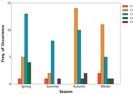
Seasonal changes for each cluster in air parcel trajectory cluster analysis with a HYSPLIT starting altitude of 1000 m.
The meteorological conditions associated with the trajectories of air parcels, which were classified into five groups, were examined.
Fig. 6 shows the air parcel trajectory for each cluster, and Fig. 7 illustrates the mean sea-level pressure and 1000 m wind distribution for each cluster. For the synoptic pattern of C1, there were strong high- and low-pressure systems northwest and southeast of the Korean Peninsula, respectively, resulting in a significant east-west pressure gradient and strong northwesterly winds. The influence of the low pressure resulted in a counterclockwise flow around mainland Japan (Fig. 7a). The air parcel trajectory of C1 was influenced by these pressure patterns. The trajectories from Mt. Baekdu were carried by northwesterly winds over the Korean Peninsula and then curved towards mainland Japan along the edge of the low-pressure system (Fig. 6b).
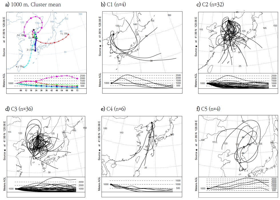
Air parcel trajectory estimated by HYSPLIT with 1000 m starting altitude (a: the mean air parcel trajectory of the cluster, b-f: the air parcel trajectories of each cluster (C1-C5)).
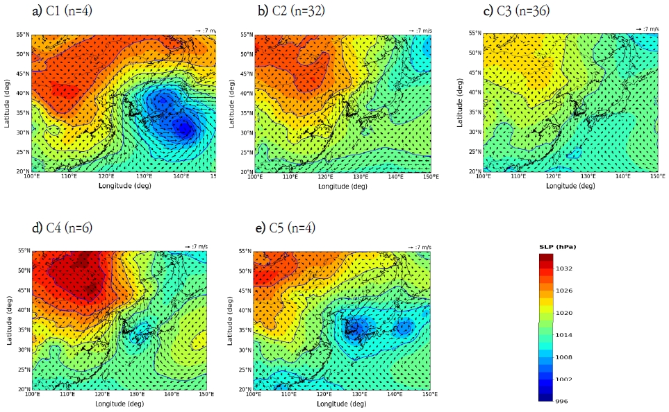
Distributions of mean sea-level pressure and 1000 hPa wind vectors on each cluster with a HYSPLIT starting altitude of 1000 m (a: C1, b: C2, c: C3, d: C4, e: C5).
During C2, the high pressure was located northwest of the Korean Peninsula, and the pressure gradient was weakly northwest to southeast, resulting in weaker north and north-northwesterly winds than those in C1 (Fig. 7b). The trajectory of this cluster was predominantly influenced by the northerly winds passing through the central and eastern regions of the Korean Peninsula before entering the southern seas (Fig. 6c). C3 exhibited a synoptic pattern similar to that of C2, but the high pressure northwest of the Korean Peninsula was weaker than that of C2. Consequently, the pressure gradient from northwest to southeast was weaker than that of C2 (Fig. 7c). Owing to weaker northerly winds, the air parcel transport path of this cluster was shorter than that of the other clusters. It passed near Gangwon Province and exited into the East Sea (Fig. 6d).
During C4, there was a strong high pressure to the northwest of the Korean Peninsula and weak low pressure to the southeast (Fig. 7d). The influence of these pressure patterns resulted in strong northerly winds and an air parcel trajectory extending from the center of the Korean Peninsula to Taiwan (Fig. 6e). For the synoptic pattern of C5, a low-pressure system was located over the Korean Peninsula, resulting in a counterclockwise flow (Fig. 7e). These synoptic patterns influenced the air parcel trajectories. The air parcels originating from Mt. Baekdu passed through the central Korean Peninsula and turned into the East Sea before arriving in northeastern China (Fig. 6f).
At an initial altitude of 1000 m, using the HYSPLIT model, air parcel trajectory cluster analysis was conducted on days when volcanic ash from Mt. Baekdu reached the receptor sites. These clusters are classified into a total of five clusters. Analysis of air parcel trajectories and synoptic patterns for the five classified clusters revealed that all clusters exhibited a northwest to southeast pressure gradient, although there were differences in the intensity of both high and low pressures among the clusters. C1, C3, and C4 are strong low-pressure systems southeast of the Korean Peninsula. In contrast, the main clusters of air parcel trajectories passing over the Korean Peninsula (C2 and C3) did not exhibit low-pressure systems in the southeastern Korean Peninsula. The air parcel trajectories in these clusters were shorter than those in the other three clusters because of the weaker pressure gradient. These results suggest that the strong low pressure in the southeastern Korean Peninsula induces a strong pressure gradient, which hinders volcanic ash flow from Mt. Baekdu into the southern part of the Korean Peninsula.
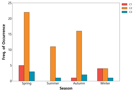
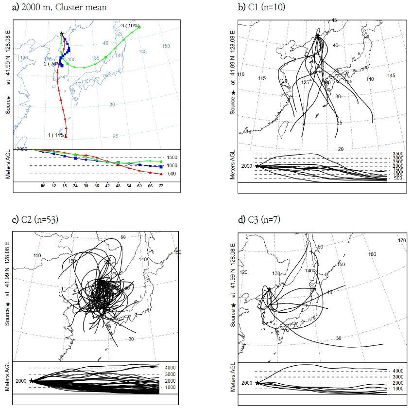
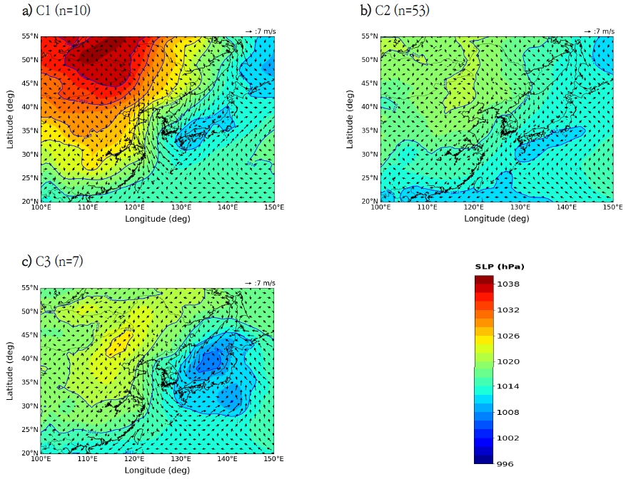
At a starting altitude of 2000 m, the air parcel trajectories passing over the Korean Peninsula were classified into three clusters (C1–C3). The reduction of clusters from at 2000 m occurs because the air parcel trajectory starting at 1000 m was directly affected by the terrain, whereas the trajectory starting at 2000 m was less affected. The occurrence frequencies for each cluster were as follows: C1 is 14.3%, C2 is 75.7%, and C3 is 10.0%. When starting at an altitude of 2000 m, volcanic ash can predominantly flow into the Korean Peninsula through the C2 trajectory (Table 3). C2 showed seasonal occurrence frequencies similar to those across the entire starting altitude of 2000 m, with the highest frequency occurring in spring, totaling 22 days (Fig. 8). For the synoptic pattern for C1, there was a strong high-pressure system located northwest of the Korean Peninsula and a low-pressure system located southeast of the Korean Peninsula, which resulted in strong northwesterly winds (Fig. 10a). Under the influence of this pressure pattern, the air trajectory from Mt. Baekdu stretched from the capital region through Jeolla Province and the southern coast to Okinawa, Japan (Fig. 9b). During C2, weak high- and low-pressure systems were positioned northwest and southeast of the Korean Peninsula, respectively. Weak northerly winds occurred because of the small pressure gradient (Fig. 10b). For this cluster, the average air trajectory was shorter than those of the other clusters, and the transport path remained near the Korean Peninsula (Fig. 9c). During C3, a high-pressure system was located northwest of the Korean Peninsula, and a low-pressure system was situated over the East Sea, resulting in northwesterly winds and counterclockwise flow along the low-pressure edge (Fig. 10c). Under the influence of these synoptic patterns, the trajectory of air parcels started from Mt. Baekdu, passed through Gangwon Province, and then curved rightward to enter the Japanese mainland (Fig. 9d).
Air parcel trajectory cluster analysis was performed on the day that the volcanic ash from Mt. Baektu reached the receptor at an initial altitude of 2000 m, and a total of three clusters were classified. C2, the main cluster in which the air parcels passed over the Korean Peninsula, exhibited a weaker intensity of the northwestern high-pressure system compared with C1 and C3, resulting in lower pressure gradients. Therefore, the weak intensity of the high-pressure system in the northwestern Korean Peninsula shortened the trajectory of the air parcel and significantly influenced the inflow of volcanic ash into the southern Korean Peninsula.
4. Conclusions
In this study, a forward trajectory analysis was performed using the HYSPLIT model to identify the occurrence frequency of days when volcanic ash from Mt. Baekdu reached the Korean Peninsula and its trajectory paths. Through cluster and synoptic analyses of these trajectories, we identified the major synoptic meteorological conditions on the days when the volcanic ash from Mt. Baekdu reached the Korean Peninsula.
The volcanic ash entered the Korean Peninsula 82 times at a starting altitude of 1000 m and 70 times at 2000 m. There is an increasing trend in volcanic ash reaching the Korean Peninsula from 2016 to 2022. This can be attributed to the weakening of westerly winds and the strengthening of the north-south winds due to global warming. In the synoptic distribution of the volcanic ash inflow to the Korean Peninsula at starting altitudes of 1000 and 2000 m, there was high pressure northwest of the Korean Peninsula and low pressure in the southeast, resulting in northerly winds. However, at 1000 m, the pressure gradient from northwest to southeast was more pronounced than that at 2000 m.
Cluster analysis of the trajectories of air parcels originating from Mt. Baekdu into the Korean Peninsula during the study period showed that for the starting altitudes of 1000 m and 2000 m, the clusters could be categorized into five and three clusters, respectively. At a starting altitude of 1000 m, air parcels originating from Mt. Baekdu mostly entered the Korean Peninsula under weather conditions with weak northerly winds (C2 and C3), owing to the small pressure gradient from northwest to southeast. This occurred in all seasons except summer. The trajectories of C2 and C3 were shorter than those of the other clusters. The average trajectory of the clusters showed that C2 descended along the east coast of the Korean Peninsula and entered the southern sea, whereas C3 passed near Gangwon Province and exited the east coast. In addition, C2 occurred frequently in autumn and winter, and C3 occurred frequently in spring and autumn. At a starting altitude of 2000 m, similar to the 1000 m results, air parcels primarily passed over the Korean Peninsula when the pressure gradient from northwest to southeast was weak. However, the path of volcanic ash inflow into the Korean Peninsula appeared simpler owing to less influence from the complex terrain, and the frequency of reaching the receptors was lower than that at 1000 m altitude. C2 had a significantly shorter trajectory than the other two clusters and moved at a slower pace. The average trajectory of the cluster starts from Mt. Baekdu, passes through the center of the Korean Peninsula, and extends into the central regions. These air parcel trajectories frequently occurred during spring. By analyzing the synoptic meteorological conditions when trajectories of volcanic ash inflow to the Korean Peninsula occurred at starting altitudes of 1000 m and 2000 m, volcanic ash from Mount Baekdu could flow into the Korean Peninsula when there was no strong low-pressure system southeast of the Korean Peninsula at an altitude of 1000 m. Conversely, at an initial altitude of 2000 m, the weakening of the Siberian high-pressure system allowed for a smaller pressure gradient, facilitating the inflow of volcanic ash from Mt. Baekdu into the Korean Peninsula.
The results of this study are expected to help determine whether volcanic ash would reach the Korean Peninsula in the event of a Mount Baekdu eruption by presenting the potential paths of volcanic ash toward the peninsula and the synoptic meteorological conditions during such an event. This information could be valuable in mitigating the impact of volcanic ash. However, the study period was set at 2-year intervals rather than covering the entire period from 2016 to 2022. Additionally, when selecting air trajectories passing through the South Korean region due to volcanic eruptions, the altitudes of the trajectories passing through this region were not considered. Therefore, conducting a more precise analysis focused on the target area is necessary by utilizing data from a longer period.
Acknowledgments
This work was supported by a 2-Year Research Grant of Pusan National University
REFERENCES
-
An, H. Y., Kang, Y. H., Song, S. K., Bang, J. H., Kim, Y. K., 2015, Atmospheric dispersion of radioactive material according to the local wind patterns around the Kori nuclear power plant using WRF/HYSPLIT model, J. Eviron. Sci., 24(1), 81-96.
[https://doi.org/10.5322/JESI.2015.24.1.81]

-
Hafner, W. D., Solorzano, N. N., Jaffe, D. A., 2007, Analysis of rainfall and fine aerosol data using clustered trajectory analysis for National Park sites in the Western US, Atmos., Environ., 41(14), 3071-3081.
[https://doi.org/10.1016/j.atmosenv.2006.11.049]

- Han, H. G., Baek, W. K., Jung, H. S., Kim, M. R., Lee, M. J., 2019, A Study on the volcanic ash damage sector selection based on the analysis of overseas cases and domestic spatial information, Korean J. Remote Sens., 35(5), 751-761.
-
Jiang, Z. H., Yu, S. Y., Yoon, S. M., Choi, K. H., 2013, Damage and socio-economic impact of volcanic ash, J. Korean Earth Sci. Soc., 34(6), 536-549.
[https://doi.org/10.5467/JKESS.2013.34.6.536]

-
Jung, W. S., Park, J. K., Lee, B. R., Kim, E. B., 2013, Analysis on the PM10 transportation route in Gimhae region using the HYSPLIT model, J. Eviron. Sci., 22(8), 1043-1052.
[https://doi.org/10.5322/JESI.2013.22.8.1043]

- Kim, D. Y., Sunwoo, Y., Park, J. E., Lee, S. S., Kim, Y. J., 2016, Study on air quality worst-case scenarios due to volcanic eruption near the Korean Peninsula using trajectory analysis, Journal of the Wind Engineering Institute of Korea, 20(1), 19-28.
- Kim, N. S., An Analysis on influence area by the simulation over Mt. Baekdu eruption, Journal of KARG, 17(3), 348-356.
- Lee, J. Y., Lee, S. S., Son, H. A., Hwang, S. T., Heo, D. Y., 2017, Probabilistic estimation of spatial distribution of volcanic ashes from Mt. Baekdu and Mt. Aso, Journal of the Wind Engineering Institute of Korea, 21(3), 113-120.
-
Lee, S. H., Jang, E. S., Lee, H. M., 2012, A Case analysis of volcanic ash dispersion under various volcanic explosivity index of the Mt. Baegdu, J. Korean Earth Sci. Soc., 33(3), 280-293.
[https://doi.org/10.5467/JKESS.2012.33.3.280]

-
Lee, S. H., Yun, S. H., 2011, Impact of meteorological wind fields average on predicting volcanic tephra dispersion of Mt. Baekdu, J. Korean Earth Sci. Soc., 32(4), 360-372.
[https://doi.org/10.5467/JKESS.2011.32.4.360]

-
Lee, S. S., Ham, H. J., Kim, Y. J., 2023, Probabilistic analysis of influence of volcanic ash from volcanoes adjacent to Korean Peninsula,Journal of the Wind Engineering Institute of Korea, 27(4), 134-151.
[https://doi.org/10.37109/weik.2023.27.4.143]

-
Lee, S. Y., Suh, G. Y., Park, S. Y., Kim, Y. S., Nam, J. H., Yu, S. H., Park, J. H., Kim, S. J., Kim, Y. S., Park, S. Y., Yun, J. Y., Jang, Y. J., Min, S. W., Noh, S. J., Kim, S. C., Lee, K. S., Chung D. Y., 2018, Prediction of dispersal directions and ranges of volcanic ashes from the possible eruption of Mt. Baekdu, Korean J. Soil Sci. Fert., 51(1), 16-27.
[https://doi.org/10.7745/KJSSF.2018.51.1.016]

-
Ma, Y. F., Du, B. Y., Wang, Q., Hu, Q. Q., Bian, Y. S., Wang, M. B., Jin, S. Y., 2019, Analysis of the atmospheric pollution transport pathways and sources in Shenyang, based on the HYSPLIT model, IOP Conf. Ser. Earth Environ. Sci., 351, 012030.
[https://doi.org/10.1088/1755-1315/351/1/012030]

-
Man, W., Zuo, M., Zhou, T., Fasullo, J. T., Bethke, I., Chen, X., Zou, L., Wu1, B., 2021, Potential influences of volcanic eruptions on future global land monsoon precipitation changes, Earth’s Future, 9(3), e2020EF001803.
[https://doi.org/10.1029/2020EF001803]

-
Nam, T. C., Ryoo, J. Y., Ryou, J. W., Kim, H. H., Park, J. Y., Kang, H. J., Kim, H. Y., Kang, K. S., Mun, D. H., Choi, J. h., Kim, H. J., 2023, A Study on the characteristics of PM2.5 and estimation of source identification in Jeollabuk-do: Focused on Iksan city, J. Korean Soc. Atmos. Environ., 39(6), 985-1006.
[https://doi.org/10.5572/KOSAE.2023.39.6.985]

-
Nauth, D., Loughner, C. P., Tzortziou, M., 2023, The Influence of synoptic-scale wind patterns on column-integrated nitrogen dioxide, ground-level ozone, and the development of sea-breeze circulations in the New York City metropolitan area, J. Appl. Meteorol. Climatol., 62(6), 645-655.
[https://doi.org/10.1175/JAMC-D-22-0145.1]

-
Nawaz, H., Tariq, S., Haq, Z. U., Mehmood, U., 2023, Identifying the natural and anthropogenic drivers of absorbing aerosols using OMI data and HYSPLIT model over South Asia, Air Quality, Atmosphere and Health, 16, 2553-2577.
[https://doi.org/10.1007/s11869-023-01423-z]

- Park, J. E., Kim, H. R., Sunwoo, Y., 2020, Analysis of PM2.5 impact and human exposure from worst-case of Mt. Baekdu volcanic eruption, Korean J. Remote Sens., 36(5), 1267-1276.
-
Park, K. H., Min, B. I., Kim, S. R., Kim, J. Y., Suh, K. S., 2020, Impacts of volcanic eruptions around the Korean Peninsula: A Long-term simulation study for hypothetical eruption scenarios, J. Korean Soc. Hazard Mitig., 20(5), 361-371.
[https://doi.org/10.9798/KOSHAM.2020.20.5.361]

-
Qor-el-aine, A., Beres, A., Geczi, G., 2021, Dust storm simulation over the Sahara Desert (Moroccan and Mauritanian regions) using HYSPLIT, Atmos. Sci. Lett., 23(4), e1076.
[https://doi.org/10.1002/asl.1076]

-
Ramirez-Hrrera, M. T., Coca, O., Vargas-Espinosa, V., 2022, Tsunami effects on the coast of Mexico by the Hunga Tonga-Hunga Ha’apai volcano eruption, Tonga, Pure Appl. Geophys., 179, 1117-1137.
[https://doi.org/10.1007/s00024-022-03017-9]

- Seo, J. B., Kang, S. R., Kim, M. C., 2016, Predicting the hazard area of the volcanic ash based on meteorological fields and the impact of weather pattern on diffusional pathway of volcanic ash, Journal of the Wind Engineering Institute of Korea, 20(1), 49-55.
-
Su, L., Yuan, Z., Fung, J. C. H., Lau, A. K. H., 2015, A Comparison of HYSPLIT backward trajectories generated from two GDAS datasets, Sci. Total Environ., 506-507, 527-537.
[https://doi.org/10.1016/j.scitotenv.2014.11.072]

-
Sun, J. S., Ahn, J. K., Lee, H. S., Hwang, E. H., Lee, D. K., 2020, Analysis of Japanese volcanic ash dispersion on the Korean Peninsula using satellite imagery, J. Korean Soc. Hazard Mitig., 20(3), 269-275.
[https://doi.org/10.9798/KOSHAM.2020.20.3.269]

-
Yun, S. H., 2013, Volcanological interpretation of historical eruptions of Mt. Baekdusan volcano, J. Korean Earth Sci. Soc., 34(6), 456-469.
[https://doi.org/10.5467/JKESS.2013.34.6.456]

-
Yun, S. H., Lee, J. H., 2012, Analysis of unrest signs of activity at the Baegdusan Volcano, Jour. Petrol. Soc. Korea, 21(1), 1-12.
[https://doi.org/10.7854/JPSK.2012.21.1.001]

Department of Earth Science, Pusan National University coekdms@pusan.ac.kr
Busan Science High School sisiwj@naver.com
Department of Earth Science Education, Pusan National University withshlee@pusan.ac.kr
